Description
The Malvern Hills are a popular spot for mountain bikers. The hills border Worcestershire, Herefordshire and Gloucestershire and are managed by the Malvern Hills Trust, an SSSI-designated landscape with over 56km of bridleways to explore. As part of their Malverns by Mountain Bike project, the Trust has waymarked three circular routes and added several permissive cycle paths to fill gaps in the bridleway network.
Like this?
The three waymarked trails are not graded for difficulty, and all follow bridleways and permissive cycle paths. All start from the North Quarry car park (pay and display), though you can join at any point along the route. Waymarker arrows colour-code each route on the ground, so no GPS is required, though GPX files are available for each. Beyond the waymarked routes, riders can explore the full bridleway and permissive path network, though it is important to understand what is and is not permitted before you head out.
Short Route
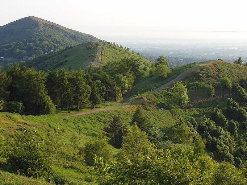
- 5.6km with 206m of climbing. Starting at North Quarry car park, the route climbs quickly to Lady Howard De Walden Drive and circuits both North Hill and Table Hill on wide, surfaced paths with good views across Herefordshire and Worcestershire, before descending back to the start. Follow the green waymarker arrows. A solid introduction to the hills and the easiest of the three options.
- Download Route Card (PDF) | Download GPX
Medium Route
- 8.7km with 260m of climbing. Heads along wide Victorian-era paths through woodland and past the historic St Ann's Well before the climb to the Gold Mine. From here you can detour to the Worcestershire Beacon, the highest point on the Malvern Hills, before looping back on the western side with views towards Wales on a clear day. Follow the orange waymarker arrows.
- Download Route Card (PDF) | Download GPX
Long Route
- 19km with 540m of climbing. Follows the Medium Route from the Gold Mine before splitting south through scenic woodland and the imposing Berrington Quarry, then a steep climb to the ridgeline at Black Hill. Refreshments and facilities at British Camp are a short 350 metre road ride from Black Hill car park. The route heads back north via Pinnacle Hill with 360-degree views before rejoining the Medium Route to the finish. The most varied of the three and the one that makes full use of the central hills permissive path network.
- Download Route Card (PDF) | Download GPX
Permissive Cycle Paths
- The Trust has added permissive cycle paths to fill gaps in the bridleway network. These are paths where cycling access has been formally granted and are not general rights of way. There are four areas: around Tank Quarry, completing the North and Table Hill circuit; two short linking sections near the West of England car park; a route through Berrington Quarry giving access to British Camp car park and its refreshment kiosk; and connecting paths around Black Hill car park, adding variety to the central hills circuit. All are shown on the Trust's walking and cycling map.
What You Can and Cannot Ride
Cycling is permitted on bridleways and on the permissive cycle paths granted by the Malvern Hills Trust. Riding outside these is a byelaw breach in this SSSI-designated landscape. Jubilee Drive and the Easier Access path from Black Hill car park are reserved for walkers and are clearly signed. Do not ride them.
The Trust operates a formal Wild Trails policy and will close informal routes that cause damage to the SSSI, archaeology or legitimate paths, or that create safety risks. In April 2026, the informal Thirds Wood route dropping to Jubilee Drive was closed: it exited onto a fast A-road at a blind bend and was causing erosion in protected woodland. Closure signage is in place, and the route should not be used.
Maps and GPX
- Route cards with directions and refreshment stops, plus GPX files for each trail, are available via the links in each route section above or from the Malvern Hills Trust mountain bike trails page. Paper copies are available from the Trust offices, local Tourist Information Centres, bike shops and cafes.
- For the full bridleway and permissive path network across the hills, download the Trust's walking and cycling maps: Map 1 and Map 2.
Share
- If you have ridden the MTB trails in the Malvern Hills and the surrounding area, then please share your pictures, reviews and videos on the listing.