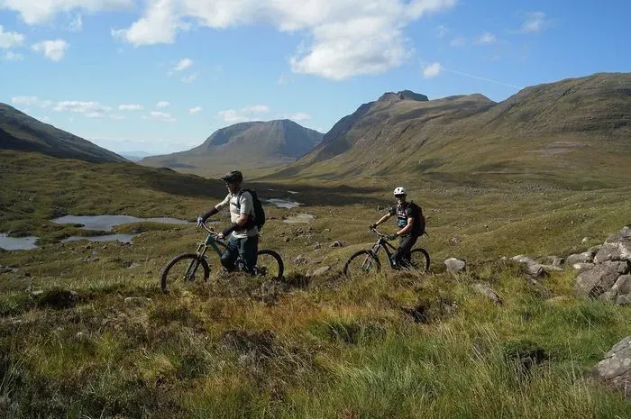
Description
Torridon, in Wester Ross in the north-west Highlands, is home to some of the finest natural singletrack in the UK. There is no trail centre here: you ride old stalkers' paths, drove roads and coffin roads through huge Torridonian sandstone mountains, linking six classic routes from 13km to around 48km. Expect rock slabs, long technical descents, tough climbs and some hike-a-bike, in a remote setting where fitness and self-sufficiency matter as much as skill.
For something less technical, the estate track over the Coulin Pass makes a scenic gravel ride between Glen Torridon and Glen Carron.
The Trails
Every route here is natural, ungraded and rough, with sections of pushing or carrying on most of them. Distances are approximate.
- Torridon Loop (around 46km): the classic. From Glen Torridon, ride east along the A896 and take the Coulin estate track over the Coulin Pass to Achnashellach, then follow the road west to Coulags. From there, climb past the Coire Fionnaraich bothy, carry up to the Bealach na Lice, and finish on the long descent to Annat before the road back.
- Coire Làir variation (around 48km): adds the climb to Drochaid Coire Làir and a steep, technical descent to Achnashellach, rated by many riders as one of the best natural descents in Scotland.
- Coire Làir and Coire Grannda (around 38km) and Coire Grannda (around 32km): shorter variations that head up the valley floor past Loch Coire Làir, with a steep, loose push to the top and an exposed, scrambly start to the descent before rideable singletrack takes you back towards the Bealach na Lice and Annat.
- Bealach na Lice to Annat (13km): the old Loch Torridon drove road from Coulags on the A890 to Annat, crossing the Bealach na Lice at 420m. The descent to Annat is narrow, twisty and rocky with the odd slab of slickrock.
- Beinn Damh Circuit (around 22km): starts from the viewpoint west of the Torridon Hotel and follows the signposted track along Loch Damh, then climbs around the south side of Beinn Damh to the bealach below Beinn na h-Eaglaise. The descent mixes fast and loose ground, with a burn crossing and a final section through woodland back to the road.
- Coire Mhic Nobuil Circuit (around 23km): ride west by road through Torridon village to the Coire Mhic Nobuil path, then push and carry through a rough 2km section below Liathach and Beinn Eighe. The reward is a 4km descent through Coire Dubh Mòr, flowing at first and then steeper and more technical, finishing back at the Coire Dubh Mòr car park.
None of the routes are waymarked, so download a route or use GPS navigation before you set off. Cycling UK has a downloadable GPX for a shorter 20km loop from Achnashellach station over the Coulin Pass and down through Coire Làir.
Gravel Riding
The Coulin Pass is the gravel ride here: around 14km of estate track and forest road between Loch Clair in Glen Torridon and Achnashellach in Glen Carron. The climb of around 250m to the pass is well graded, the going is firm apart from short boggy stretches near Loch Coulin, and the lochside road at Loch Clair looks straight across to Liathach. It is a linear route, so ride it out and back, or finish at Achnashellach station on the Inverness to Kyle of Lochalsh line.
Before You Ride
- There are no facilities anywhere on these routes. Carry food, water, spare tubes, brake pads and tools: the rock here causes plenty of pinch flats.
- Much of the land north of Glen Torridon is cared for by the National Trust for Scotland, while several routes cross private estates. Follow the Scottish Outdoor Access Code, stay on the line of the path, avoid skidding on wet, peaty ground, and in late summer and autumn check Heading for the Scottish Hills for deer stalking on the estates.
- Guided rides are available locally from The Torridon, which offers half-day sessions with bike hire, and from Elite Guides MTB, who cover the Annat descent, Achnashellach and the Beinn Damh loop.
Getting Here
- Coire Dubh Mòr car park, A896, Glen Torridon: from Kinlochewe take the A896 towards Shieldaig and follow it for about 6 miles. The car park is on the right. It is popular with walkers and climbers and fills up quickly on busy days.
- Alternative starts: Annat, at the head of Loch Torridon, for the Bealach na Lice path; the Coire Mhic Nobuil path west of Torridon village; Loch Clair for the Coulin Pass; and Coulags on the A890 in Glen Carron for the southern approach.
- By train and bus: Achnashellach and Strathcarron stations are on the Inverness to Kyle of Lochalsh line, and a limited bus service links Strathcarron with Torridon.
Share
- If you have visited Torridon Mountain Bike Trails, please share your reviews, photos, and videos to this listing.